Article on the evaluation of gridded soil moisture products published in HESS
On January 12th, 2026, Hydrology and Earth System Sciences (HESS) published our article entitled From grid to ground: how well do gridded products represent soil moisture dynamics in natural ecosystems during precipitation events?. This study investigates how spatial patterns, temporal trends, and record length in hourly precipitation data affect annual maximum intensities estimated with stationary and non-stationary models across a climatically and topographically diverse region.
Motivation
Soil moisture is a key variable controlling how water moves through landscapes, supports vegetation, and interacts with the atmosphere. It plays a central role in drought monitoring, ecosystem management, and hydrological modelling. In many regions—particularly natural or remote ecosystems—direct soil moisture measurements are scarce. As a result, scientists and practitioners often rely on large-scale datasets derived from satellites or land surface models. This study evaluates how accurately these datasets represent soil moisture dynamics across Chile’s wide range of climates, from arid northern zones to humid southern forests.
What was the novelty?
The study assessed four widely used soil moisture datasets, ERA5, ERA5-Land, SMAP-L4, and GLDAS-Noah, against detailed field observations collected every three hours from the Kimün-Ko monitoring network. The monitoring sites span ten near-natural ecosystems along Chile’s hydroclimatic gradient.
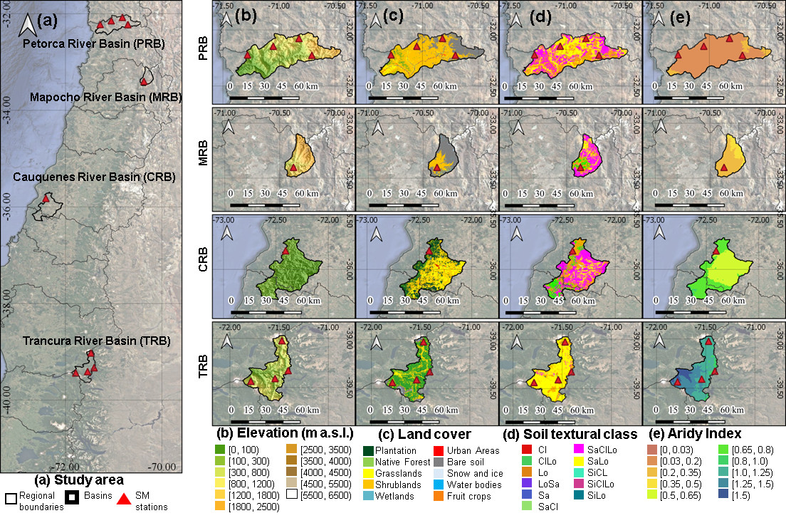
Study area: (a) catchment location (CAMELS-CL; Alvarez-Garreton et al., 2018); (b) elevation (SRTMv4.1; Jarvis et al., 2008); (c) land cover classification (CLDynamicLandCover.V2; Galleguillos et al., 2024); (d) soil properties (CLSoilMaps; Dinamarca et al., 2023); and (e) aridity index (AI=P/PET) 1970–2000 (Global-AI-PET-v3; Zomer et al., 2022).
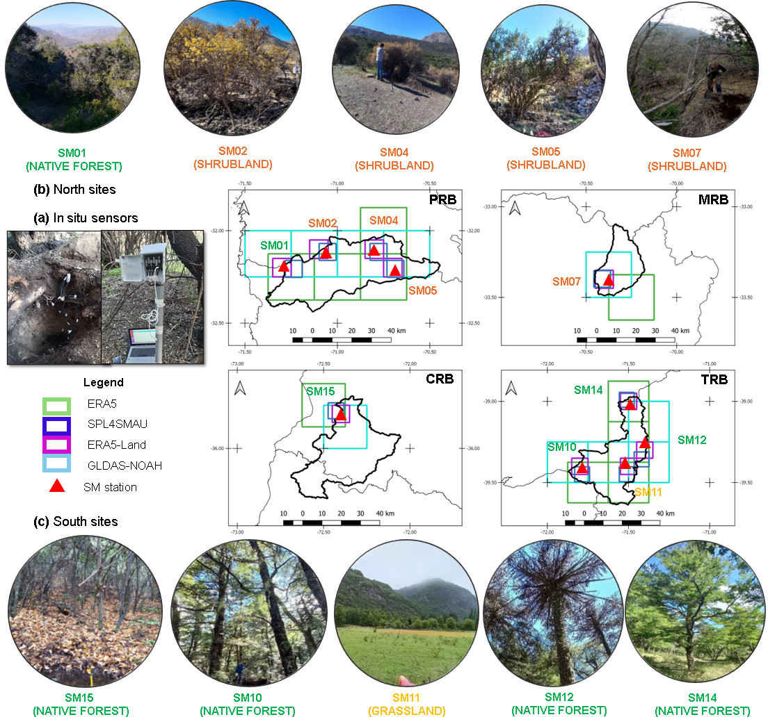
Locations of in situ TEROS 10 and TEROS 12 sensors. (a) Example of TEROS 10 and TEROS 12 sensors installed across various land cover types; (b) northern arid sites in the Petorca (PRB) and Mapocho (MRB) river basins; and (c) southern humid sites in the Cauquenes (CRB) and Trancura (TRB) river basins. Red triangles indicate the locations of in situ SM monitoring sites. Grid cell boundaries of each gridded SM product are shown for ERA5 (green), ERA5-Land (purple), SPL4SMAU (blue), and GLDAS-Noah (lightblue).
In addition to standard statistical indicators, the researchers applied an event-based diagnostic method that examines how soil moisture responds to individual rainfall events. This approach evaluates both the magnitude of the response and how quickly the soil becomes wetter after rainfall.
What we found
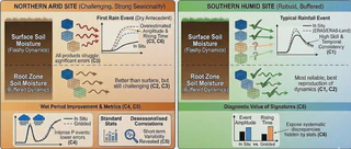
The evaluation revealed consistent patterns with direct implications for environmental monitoring and modelling:
-
ERA5 and ERA5-Land showed the most reliable overall performance. These datasets reproduced seasonal soil moisture dynamics reasonably well across most regions, particularly in the wetter southern ecosystems.
-
Deeper soil layers were simulated more accurately than surface layers. Root-zone soil moisture changes more slowly and is less sensitive to short-term fluctuations, making it easier for large-scale models to represent.
-
Arid regions remain difficult to simulate. In northern ecosystems, all datasets struggled to reproduce the first rainfall response after long dry periods, typically overestimating how much and how quickly soil moisture increased.
-
Performance varies by product and location. Some datasets performed well under specific conditions—for example, one showed relatively strong skill for surface soil moisture in selected arid sites—while others systematically underestimated soil moisture in wetter environments.
Schematic summary of the main conclusions.
Why the new diagnostic approach is important
A key contribution of the study is the demonstration that traditional performance metrics can overlook important timing and response errors. A dataset may appear accurate when evaluated over long periods but still fail to capture the rapid changes that occur during individual storms. Event-based diagnostics provide a clearer understanding of how models represent real hydrological processes, especially during extreme or short-lived events.
Why this matters for practice and decision-making
The findings provide practical guidance for selecting soil moisture datasets in regions where field measurements are limited. In particular, identifying the most reliable products supports better drought monitoring, improved hydrological simulations, and more informed ecosystem and water resource management.
Our study also highlights the importance of evaluating not only average performance, but also the dynamic response of soils to rainfall—an aspect that becomes increasingly critical under changing climate conditions.
The full article can be found here: https://doi.org/10.5194/hess-30-1813-2026.

I am an Associate Professor in the Department of Civil Engineering at the University of La Frontera. I hold a PhD in Environmental Engineering from the University of Trento (Italy) and completed postdoctoral training at the European Commission’s Joint Research Centre. I have more than 20 years of experience in water resources research and have previously served as an Associate Researcher at the Center for Climate and Resilience Research (CR)2 and as a member of the Earth Sciences Assessment Group of the Chilean National Research and Development Agency (ANID).
My research lies at the interface of hydrology, data science, and environmental sciences, with a particular focus on the use of gridded datasets and open-source tools to investigate droughts, extreme events, and water-related impacts of global change.
I work across spatial and temporal scales to improve the understanding of catchment-scale hydrological processes and to translate this knowledge into operational modelling, forecasting, and early-warning systems that support robust environmental decision-making.
Please reach out to collaborate 😃