Article on hydropedological clustering published in JoH
On December 19th, 2025, Journal of Hydrology published our article entitled Hydropedological clustering: improving the representation of low streamflows in a semi-distributed hydrological model. This study investigates how different soil datasets and classification approaches affect the performance of the SWAT+ hydrological model in simulating low streamflows and soil water content (SWC).
Motivation
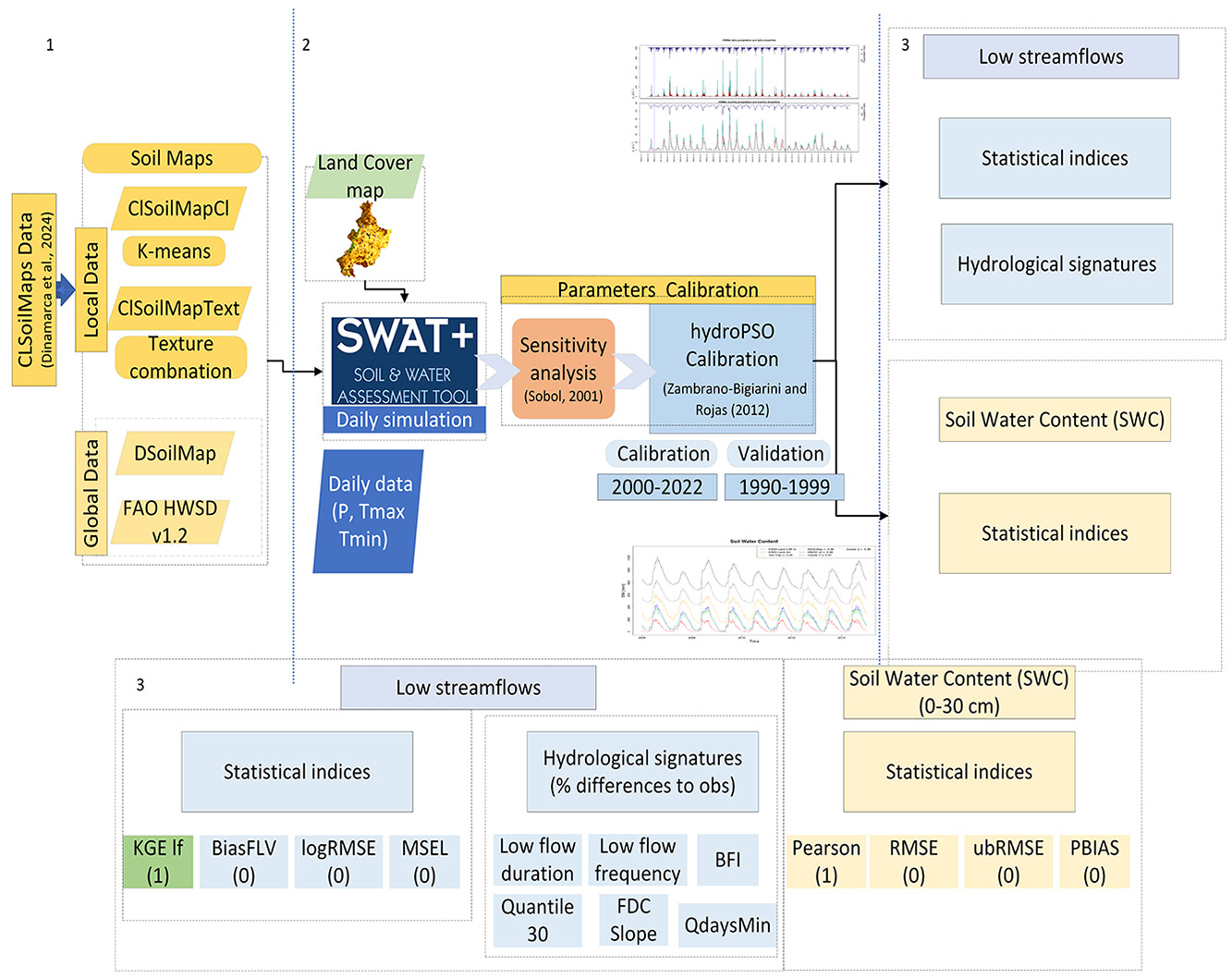
In Mediterranean climates, such as central Chile, rivers often experience very low flows during long dry seasons. These low flows are critical for agriculture, drinking water supply, and ecosystem health. Yet they remain difficult to be reliably simulated because the way soils store and release water is complex and varies substantially across the landscape. Many hydrological models rely on global soil databases that do not fully capture local soil behavior. This study evaluates a new method for organizing soil information, called hydropedological clustering, to improve the simulation of low streamflows in the Cauquenes catchment.
What is new in this approach
The researchers compared four different soil datasets, including widely used global maps and locally developed soil information. They introduced a new clustering strategy that groups soils according to key soil hydraulic properties that directly control water movement and storage:
- Saturated hydraulic conductivity, which governs how quickly water can move through soil
- Available water capacity, which determines how much water soil can retain for plants
- The van Genuchten α parameter, which reflects soil pore structure
Rather than classifying soils only by texture (sand, silt, and clay), this method focuses on how soils actually function hydrologically. The result is a more meaningful representation of soil processes within the model.
What the study found
The hydropedological clustering method produced consistently better results than conventional soil classifications. It improved the accuracy of low-flow simulations, reproduced key hydrological indicators more realistically, and reduced model calibration time. The approach also provided more reliable estimates of soil moisture across the root zone, avoiding the large overestimations often associated with coarse global datasets. A central conclusion is that how soils are classified can matter more than how detailed the map resolution is!.
Why this is important for water management
Reliable low-flow simulations are essential for managing water during droughts, when supply is limited and demand is high. Improved modelling supports better decisions on water allocation, irrigation planning, environmental flow protection, and energy production. The study demonstrates a practical and transferable framework for integrating locally relevant soil knowledge into hydrological models. This capability is particularly valuable for regions facing increasing water stress under climate variability and prolonged drought conditions.
The full article can be found here: https://doi.org/10.1016/j.jhydrol.2025.134787.
Graphical abstract

I am an Associate Professor in the Department of Civil Engineering at the University of La Frontera. I hold a PhD in Environmental Engineering from the University of Trento (Italy) and completed postdoctoral training at the European Commission’s Joint Research Centre. I have more than 20 years of experience in water resources research and have previously served as an Associate Researcher at the Center for Climate and Resilience Research (CR)2 and as a member of the Earth Sciences Assessment Group of the Chilean National Research and Development Agency (ANID).
My research lies at the interface of hydrology, data science, and environmental sciences, with a particular focus on the use of gridded datasets and open-source tools to investigate droughts, extreme events, and water-related impacts of global change.
I work across spatial and temporal scales to improve the understanding of catchment-scale hydrological processes and to translate this knowledge into operational modelling, forecasting, and early-warning systems that support robust environmental decision-making.
Please reach out to collaborate 😃