Pulliko: Gridded soil moisture for Chile
 My Caption
Context and motivation
Reliable monitoring of soil moisture is essential for understanding water availability, managing drought risk, and supporting sustainable water resources management. Soil moisture regulates key hydrological processes such as infiltration, runoff, evaporation, and plant water uptake, and plays a central role in land–atmosphere interactions. Conditions in the surface soil layer (SSM; 0–10 cm) respond rapidly to rainfall events, while moisture in the deeper root zone (RZSM; 0–100 cm) evolves more slowly and sustains vegetation during dry periods, influencing the onset and persistence of extreme events such as droughts and intense rainfall.
Accurate representation of these dynamics requires spatially continuous information derived from multiple data sources. Ground-based measurements provide high-quality observations but are geographically sparse, particularly in the Southern Hemisphere. Satellite observations offer broad and frequent coverage, yet they primarily capture near-surface conditions and can be affected by vegetation and environmental factors. Therefore, integrating diverse datasets within a unified monitoring framework is therefore critical for delivering timely, reliable information on soil moisture conditions across large and climatically diverse regions such as Chile, where environmental conditions range from the hyper-arid north to the humid south.
Description
In response to this need, during her undergraduate thesis, Rocío Muñoz Neira developed under my supervision an operational web platform designed to provide near real-time monitoring of soil moisture and its anomalies across continental Chile. The platform integrates multiple high-quality datasets to deliver timely, spatially consistent information that can support decision-making in agriculture, water resources management, environmental monitoring, and scientific research.
Four state-of-the-art gridded soil moisture products were selected based on their long-term data availability, spatial and temporal resolution, and operational reliability. These products provide volumetric soil moisture estimates for both the surface soil layer (0–10 cm) and the root zone soil layer (0–100 cm). The four available gridded soil moisture products are:
- ERA5 (0.25° spatial resolution, hourly updates, approximately 6-day latency),
- ERA5-Land (0.1°, hourly, approximately 6-day latency),
- GLDAS-Noah (0.25°, three-hourly, approximately 4-month latency), and
- SMAP-L4 (9 km resolution, three-hourly, approximately 2.5-day latency).
The following article evalautes the four previous soil moisture datasets against in situ measurements:
- Núñez-Ibarra, D. A.; Zambrano-Bigiarini, M.; Galleguillos, M. (2026). From grid to ground: how well do gridded products represent soil moisture dynamics in natural ecosystems during precipitation events?. Hydrology and Earth System Sciences, 30, 1813–1847. https://doi.org/10.5194/hess-30-1813-2026.
Together, these complementary soil moisture datasets offer robust coverage across a wide range of climatic and hydrological conditions.
To enhance the interpretation of soil moisture conditions, the platform also computes two standardised drought indicators of soil moisture anomalies:
-
The Standardized Soil Moisture Index (SSMI) is a parametric indicator based on the gamma probability distribution, while
-
the Empirical Standardized Soil Moisture Index (ESSMI) is a non-parametric indicator derived using kernel density estimation techniques.
These indices are calculated automatically on a daily basis at multiple temporal aggregation scales (1, 3, 6, 12, and 24 months), allowing users to assess short-term variability as well as longer-term hydrological trends.
The system operates through a fully automated data pipeline. External data servers are queried regularly to identify the most recent observations, which are then downloaded, processed, and stored on the internal infrastructure of the Water Resources Observatory Kimün-Ko of the Department of Civil Engineering at the Universidad de La Frontera. The processed soil moisture fields and derived anomaly indicators are subsequently displayed through the Pulliko, meaning “water in the soil” in mapuzungun, interactive web interface, enabling users to explore current conditions and historical patterns in an intuitive and accessible manner.
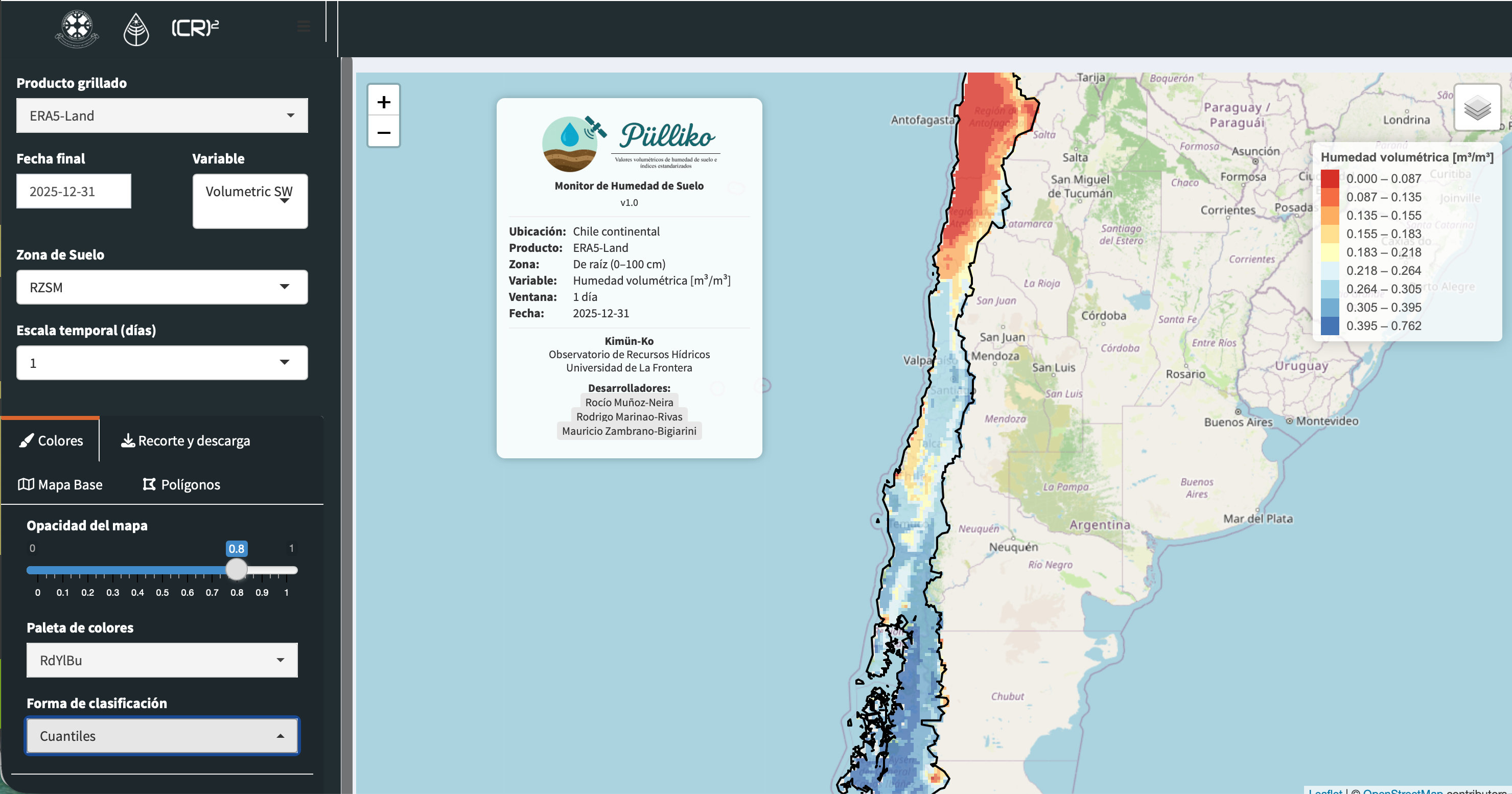
Main screen of Pulliko web platform
By combining reliable data sources, automated processing, and interactive visualization tools, this platform provides a practical and scientifically robust resource for monitoring soil moisture dynamics across Chile. Its near real-time capabilities support informed decision-making, improve situational awareness during hydrological extremes, and contribute to a better understanding of the country’s evolving water and climate conditions.
Additional information about the development of this platform can be found in the undergraduate thesis of Rocío Muñoz.

I am an Associate Professor in the Department of Civil Engineering at the University of La Frontera. I hold a PhD in Environmental Engineering from the University of Trento (Italy) and completed postdoctoral training at the European Commission’s Joint Research Centre. I have more than 20 years of experience in water resources research and have previously served as an Associate Researcher at the Center for Climate and Resilience Research (CR)2 and as a member of the Earth Sciences Assessment Group of the Chilean National Research and Development Agency (ANID).
My research lies at the interface of hydrology, data science, and environmental sciences, with a particular focus on the use of gridded datasets and open-source tools to investigate droughts, extreme events, and water-related impacts of global change.
I work across spatial and temporal scales to improve the understanding of catchment-scale hydrological processes and to translate this knowledge into operational modelling, forecasting, and early-warning systems that support robust environmental decision-making.
Please reach out to collaborate 😃